- Home
- GrassyMountainGold
- info@paramountnevada.com
- 844-488-2233
-
 Subscribe
SubscribeGrassy Mountain Project
Vale, Oregon, USA
Lattitude 38.348288
Longitude -114.680978
N 38º 20'53"
W 114º 40'51"
Overview
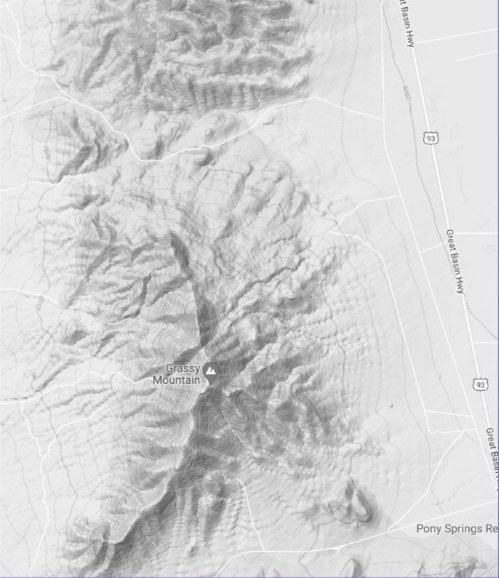
Overview and Location
The Grassy Mountain Gold Project (“Grassy”) is located in Malheur County, eastern Oregon, approximately 22 miles south of Vale, Oregon, and roughly 70 miles west of Boise, Idaho. The project site is situated in the rolling hills of the high desert region of the far western Snake River Plain and consists of 3 patented (private) lode claims where the deposit is located, 462 unpatented lode claims, 9 mill site claims, 6 associated placer claims, and a lease for land surface and surface/mineral rights, all totaling approximately 8,200 acres. The local terrain is gentle to moderate, with elevations ranging from 3300 to 4,300 ft. above mean sea level. We own 100% of the private land on which the gold deposit sits and control all mining claims within the 8,200 acres land package.
Following the acquisition of Calico Resources in 2016, we have been focused on advancing the high-grade Grassy Mountain project towards production. Building off an initial Pre-Feasibility Study (“PFS”) in 2018, we completed a robustly economic Feasibility Study (“FS”) in the fall of 2020 while continuing to advance the project through county, state, and Federal permitting.
Feasibility Study
On October 29, 2020, we filed the NI-43-101 Technical Report on the Feasibility Study for the proposed high-grade, underground mining operation at Grassy Mountain. The base case scenario gold and silver prices used in the FS were $1,472 and $16.64 respectively. The highlights of the study are as follows:
The highlights of the study are as follows:
• Initial CapEx of $97.5 million, $10.1M of estimated contingencies, $25.6M of sustaining CapEx and $6.3M closure costs for a 750 tpd mine and milling operation;
• Annual production of approximately 47,000 ounces of Au and 55,000 ounces of Ag over an initial 8-year mine life with a 3.1 year after-tax payback period;
P&P reserves containing 390,000 ounces of Au and 425,000 ounces of silver;
• Average mill head grade of approximately 6.5g/T;
• Life of mine cash costs of $584 and AISC of $672 per ounce of gold;
• Total after-tax free cash flow of $165M; and
• After tax IRR of 26% and NPV (5%) of $123 million at the base case metal prices.
Permitting of Grassy Mountain
Paramount has continued to achieve permitting milestones at all levels of government. At the County level the Company has received its Conditional Use Permit; at the state level the Company received its permit to appropriate water, the first Oregon State agency permit received as part of the Consolidated Permitting process; and at the federal level, the Company has submitted its Plan of Operation with the Federal Bureau of Land Management.
Conditional Use Permit
County Level
In mid-2019, we announced the approval of the Conditional Use Permit (“CUP”) for the proposed Grassy Mountain underground mine from Malheur County. During a public meeting held in May 2019, the Malheur County Planning Commission (the “Planning Commission”) voted unanimously to approve the CUP and to recommend approval of a Sage Grouse Rule Permit to the Malheur County Court. The approval of the CUP is a major milestone for our Company and exemplifies the level of commitment and support from the local communities as we continue our quest to advance Grassy Mountain towards construction. The Planning Commission has granted us an extension of the CUP through May 2023.
As the permit name indicates, the county issued the CUP with conditions, which in the case of Grassy Mountain, are the following:
1. The applicant will subscribe to the Vale rangeland fire protection Association;
2. The applicant shall collaborate with the Malheur County sheriff’s office in regard to a security plan as well as law enforcement and emergency response plans;
3. Any road improvements necessary to serve Grassy Mountain must be constructed according to county design standards to the satisfaction of the County Road Master; and
4. The applicant shall obtain approval for its reclamation plan from Oregon Department of Geology and Mineral Industries (“DOGAMI”), prior to beginning mining operations. Unless otherwise prohibited by DOGAMI, the Applicant may conduct pre-construction and construction activities prior to obtaining approval for its reclamation plan.
Consolidated Permit Application
State Level
The completion of the PFS in May 2018 was an integral component in completing the permit approval process. Throughout 2018 and 2019, the team worked diligently to submit the baseline data reports (“BDR”) which were included within the Consolidated Permit Application (“CPA”) submitted to the DOGAMI in November 2019.
In January of 2020, Paramount was granted the water appropriation permit from the Oregon Water Resources Department (“OWRD”). This permit provides for a sufficient quantity of water for the proposed mining and processing operations throughout the mine life as detailed in the CPA.
Permitting success continued for Grassy with the OWRDs review of tailings data contained in the CPA. The OWRD approved the plans and specifications of the proposed tailings dam assigning the dam a low hazard risk rating, its lowest risk level. Additionally, the OWRD stated that the plans are construction ready from a safety perspective.
The DOGAMI and cooperating agencies completed their initial review of the CPA and have provided Paramount a list of supplemental information and recommendations required to submit a modified CPA. Paramount is currently working collaboratively with the state agencies to complete the modified CPA which will trigger the 225-day maximum permit evaluation process, upon which draft permits are issued.
Plan Of Operation / Environmental Impact Statement
Federal Level
In February 2020, Paramount submitted an amended Plan of Operation (“PoO”) with the Federal Bureau of Land Management (“BLM”) to continue with the federal Environmental Impact Statement (“EIS”) in accordance with the previously filed PoO which Paramount filed in September 2017.
Paramount has received initial comments from the BLM’s review of the PoO submitted by Paramount in early 2020. The Company is in the process of addressing the comments received which will be included in an amended POO that it will submit to the BLM. Once the BLM accepts the POO as complete they will register a Notice of Intent with the Federal Register thereby triggering the initiation of the Environmental Impact Statement (“EIS”) which will be completed by HDR Inc. The EIS process is expected to take 12 months.
Exploration Potential
Post the review of historical data and the results of a helicopter mag and radiometric survey that Paramount conducted on its entire 9,530 acre claim area to map structures and magnetic anomalies, the company has identified several targets with the potential to add to the existing mineralized material inventory and to extend mine life thereby enhancing the already robust economics identified in the Feasibility Study.
These targets include:
↵
Currently, we have not set a time frame to drill test the exploration targets as we are focusing our resources on the submission of the State and Federal permits.

Cautionary Note to U.S. Investors Concerning Estimates of Indicated, Inferred Resources and Reserves
This web site uses the terms “measured and indicated resources”, “inferred resources” and “proven and probable reserves”. We advise U.S. investors that while these terms are defined in, and permitted by, Canadian regulations, these terms are not defined terms under SEC Industry Guide 7 and not normally permitted to be used in reports and registration statements filed with the SEC. “Inferred resources” have a great amount of uncertainty as to their existence, and great uncertainty as to their economic and legal feasibility. It cannot be assumed that all or any part of an inferred mineral resource will ever be upgraded to a higher category. Under Canadian rules, estimates of inferred mineral resources may not form the basis of a feasibility study or pre-feasibility studies, except in rare cases. The SEC normally only permits issuers to report mineralization that does not constitute SEC Industry Guide 7 compliant “reserves”, as in-place tonnage and grade without reference to unit measures. U.S. investors are cautioned not to assume that any part or all of mineral deposits in this category will ever be converted into reserves. U.S. investors are cautioned not to assume that any part or all of an inferred resource exists or is economically or legally mineable. Under SEC Industry Guide 7 standards, a “final” or “bankable” feasibility study is required to report reserves, the three-year historical average price is used in any reserve or cash flow analysis to designate reserves and the primary environmental analysis or report must be filed with the appropriate governmental authority.
 Technical Reports

October 2020
2020 -10-29 NI 43-101 Technical Report on Feasibility Study for Grassy Mountain Gold Project
July 2018
2018 -07-09 NI 43-101 Technical Report on PFS for Grassy Mountain Gold Project
July 2015
2015-07-09 Grassy Moutain Gold Project Amended Technical Report
Resources
Mineral Resources
| Class | TonsI (millions) | Au (opt) | Au (ozs) | Ag (opt) | Ag (ozs) |
| Measured | 18.19 | 0.020 | 369,000 | 0.079 | 1,438,000 |
| Indicated | 12.71 | 0.054 | 691,000 | 0.146 | 1,861,000 |
| Measured + Indicated* | 30.90 | 0.034 | 1,060,000 | 0.107 | 3,299,000 |
| Inferred | 1.00 | 0.041 | 41,000 | 0.120 | 120,000 |
I in imperial tons
*Grassy Mountain mineral resources are inclusive of the mineral reserves.
Mineral Resources
| Class | TonnesII (millions) | Au (g/T) | Au (ozs) | Ag (g/T) | Ag (ozs) |
| Measured | 16.50 | 0.69 | 369,000 | 2.71 | 1,438,000 |
| Indicated | 11.53 | 1.85 | 691,000 | 5.01 | 1,861,000 |
| Measured + Indicated* | 28.03 | 1.17 | 1,060,000 | 3.67 | 3,299,000 |
| Inferred | 0.91 | 1.41 | 41,000 | 4.11 | 120,000 |
IIin metric tonnes
*Grassy Mountain mineral resources are inclusive of the mineral reserves.
Mineral Resources
| Class | Tonsa (millions) | Au (opt) | Au (ozs) | Ag (opt) | Ag (ozs) |
| Proven | 0.26 | 0.18 | 46,987 | 0.26 | 68,421 |
| Probable | 1.65 | 0.20 | 333,036 | 0.29 | 485,522 |
| Proven & Probable | 1.91 | 0.20 | 380,023 | 0.29 | 553,943 |
| Ore Loss & Dilution | 0.16 | 0.06 | 9,910 | 0.15 | 24,336 |
| P&P + Ore Loss & Dilution | 2.07 | 0.19 | 389,933 | 0.28 | 578,279 |
a in imperial tons
Mineral Resources
| Class | Tonnesb (millions) | Au (g/T) | Au (ozs) | Ag (g/T) | Ag (ozs) |
| Proven | 0.24 | 6.21 | 46,987 | 9.04 | 68,421 |
| Probable | 1.49 | 6.91 | 333,036 | 10.08 | 485,522 |
| Proven & Probable | 1.73 | 6.82 | 380,023 | 9.94 | 553,943 |
| Ore Loss & Dilution | 0.14 | 2.14 | 9,910 | 5.26 | 24,336 |
| Proven & Probable | 1.87 | 6.46 | 389,933 | 9.58 | 578,279 |
b in imperial tons
Source: Grassy Mountain Technical Report on FS filed on SEDAR
October 29, 2020
Cautionary Note to U.S. Investors Concerning Estimates of Indicated, Inferred Resources and Reserves
This news release uses the terms “measured and indicated resources”, “inferred resources” and “proven and probable reserves”. We advise U.S. investors that while these terms are defined in, and permitted by, Canadian regulations, these terms are not defined terms under SEC Industry Guide 7 and not normally permitted to be used in reports and registration statements filed with the SEC. “Inferred resources” have a great amount of uncertainty as to their existence, and great uncertainty as to their economic and legal feasibility. It cannot be assumed that all or any part of an inferred mineral resource will ever be upgraded to a higher category. Under Canadian rules, estimates of inferred mineral resources may not form the basis of a feasibility study or prefeasibility studies, except in rare cases. The SEC normally only permits issuers to report mineralization that does not constitute SEC Industry Guide 7 compliant “reserves”, as in-place tonnage and grade without reference to unit measures. U.S. investors are cautioned not to assume that any part or all of mineral deposits in this category will ever be converted into reserves. U.S. investors are cautioned not to assume that any part or all of an inferred resource exists or is economically or legally minable. Under SEC Industry Guide 7 standards, a “final” or “bankable” feasibility study is required to report reserves, the three-year historical average price is used in any reserve or cash flow analysis to designate reserves and the primary environmental analysis or report must be filed with the appropriate governmental authority.
Geology
Grassy Mountain is the largest of twelve recognized epithermal hot spring precious metal deposits of the Lake Owyhee volcanic field. The Lake Owyhee volcanic field occurs at the intersection of three tectonic provinces: the buried cratonic margin, the northern Basin and Range, and the Snake River Plain. During the mid-Miocene caldera volcanism occurred in the shallow crust throughout the region, predominately ash-flow sheets and rhyolite tuff cones. The resulting regional stratigraphic section is a thick sequence of mid-Miocene volcanic rocks and coeval-to-Pliocene age non-marine lacustrine, volcaniclastic, and fluvial sedimentary rocks.

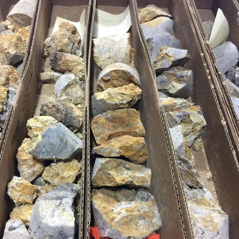
Bedrock outcrops in the vicinity of the Grassy Mountain property are typically composed of olivine-rich basalt and siltstones, sandstones, and conglomerates of the late Miocene Grassy Mountain Formation. These rocks are locally covered with relatively thin, unconsolidated alluvial and colluvial deposits. Erosion-resistant basalts cap local topographic highs. Arkosic sandstones have been encountered at the surface and at depth, but have not been correlated across the project area, in part due to lateral discontinuity associated with sedimentary facies changes and structural offset.
The basal unit to the Grassy Mountain Formation is the Kern Basin Tuff, a non-welded, pumiceous, crystal tuff which displays cross beds and local surge structures. The Kern Basin Tuff ranges in thickness from 300 ft on the south bluffs of Grassy Mountain, to 1,500 ft in a drill hole beneath the Grassy Mountain Project area.
The Kern Basin Tuff is overlain by a series of fluvial, lacustrine, and tuffaceous sediments. Most of the sedimentary units in the project area are silicified and strongly indurated. These sedimentary units include granitic clast conglomerate, arkosic sandstone, fine grained sandstone, siltstone, and tuffaceous siltstone/mudstone. The sedimentary facies of the Grassy Mountain Formation reportedly range from 300 to over 1,000 ft thick, and provide the host rocks of the Grassy Mountain mineral resource.
Several siliceous terraces are interbedded with the silicified sediments of the Grassy Mountain Formation. Terrace construction was apparently episodic and intermittently inundated by fluvial/lacustrine sediments and ash, resulting in an interbedded sequence of siltstone, tuffaceous siltstone, sandstone, conglomerate, and sinter terrace deposits. Proximal deposits are angular, inhomogeneous, clast-supported breccias of sandstone, siltstone, and sinter with indistinct clast boundaries in a sulfidic mud-textured matrix.
Grassy Mountain is a prominent, 150 ft. high, silicified and iron-stained knob. Bedding is approximately horizontal at the hilltop, and dips at 10° to 25° to the north-northeast on the northern and eastern flanks of the hill. The bedding dip steepens to 30° to 40° on the west side of the hill due to drag folding in the footwall of the N20W striking Antelope Fault. The southwest slope of Grassy Mountain is covered by silicified arkose landslide debris.
Grassy Mountain is a horst block which has been raised 50 to 200 ft. in a region of complex block faulting and rotation. Faulting at Grassy Mountain is dominated by post-mineral N30W to N10E striking normal faults developed during Basin and Range extension. On the northeast side of the deposit, these faults progressively down-drop mineralization beneath post-mineral cover. These offsets are suggested by interpreted offsets of a prominent white sinter bed in drill holes as well as intersections with fault gouge. The N70E striking Grassy Mountain Fault shows minor vertical offset of only 10 to 40 ft.
The surface expression of the Grassy Mountain system is indicated by weak to moderately strong silicification and iron staining with scattered chalcedonic veins/veinlets. Approximate dimensions of the Grassy Mountain deposit are 1600 ft. long by 1000 ft. wide by 600 ft. thick. The deposit has a general N70 E elongation and a 15° bedding plane dip to the north-northeast as a result of faulting and fault block rotation. There is an envelope of lower grade mineralization at depths of 200 to 800 ft. which contains a higher-grade zone of mineralization between 500 and 750 ft. below the surface. The well-defined base of higher grade mineralization from about 700 to 750 ft. in depth suggests a strong pressure-temperature control on gold deposition. Sinters and breccias parallel the paleosurface present at the time of mineralization. Fractures created a stockwork pattern generally found below the sinter, though some vein extensions may extend to the surface. The stockwork is surrounded by silicified sediments.
Mineralized quartz-adularia stockwork and vein types include single, banded, colliform, brecciated, and calcite-pseudomorphed veins. Visible gold (0.5 mm) has been found within the stockwork portions of the boiling horizon. The gold mostly occurs as electrum along the fracture margins or within microscopic voids. A brassy color is imparted due to the high silver content. The average silver to gold ratio at Grassy Mountain is 2.5:1.
Silicification occurs both pervasively as silica flooding and as cross-cutting veins, veinlets and stockworks. The silicified envelope has plan dimensions of 3000 ft (N-S) by 2500 ft (E-W). Silicification is surrounded by barren, relatively unaltered, clay-rich (20-40% montmorillonite), tuffaceous siltstone and arkose with minor disseminated diagenetic pyrite. Many of the sinters occur as sheets instead of mounds, which suggests that they may be related to vents along faults rather than point sources. Potassic alteration occurs as adularia flooding with destruction of biotite. The adularia is extremely fine-grained and is identified microscopically or by cobaltinitrite staining. Sulfate phases identified by XRD include jarosite and alunite in several mineralized samples. Clast-supported breccias contain sub-rounded to sub-angular sand to boulder-sized clasts of silicified arkose and siltstone in a jarosite-sericite clay matrix.